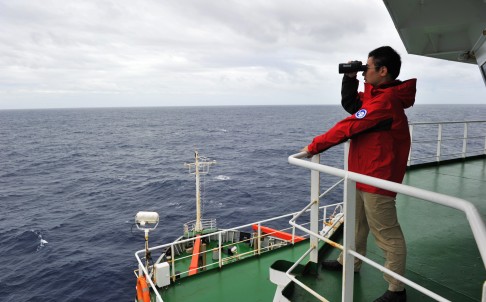
A crew member of Chinese icebreaker Xuelong searches for the missing Malaysia Airlines Flight MH370 on the south Indian Ocean on March 23, 2014. Photo: Xinhua
France on Sunday became the third nation to provide satellite images of "objects" that could be related to the disappearance of missing Malaysia Airlines flight MH370.
Malaysia received the new satellite images from French authorities, the third such satellite images in a week, showing objects possibly related to the missing Malaysian Airlines aircraft in the southern Indian Ocean, adding to growing signs that the plane may have gone down in remote seas off Australia.
The latest lead comes as the international search for Malaysian Airlines Flight MH370 entered its third week, with still no confirmed trace of the Boeing 777 that vanished with 239 people on board.
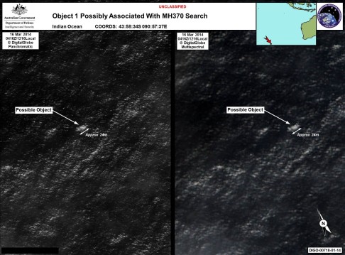
Previously, Australia and China both released satellite images showing objects floating in the Indian Ocean.
"This morning, Malaysia received new satellite images from the French authorities," Malaysia’s transport ministry said in a statement. "Malaysia immediately relayed these images to the Australian rescue co-ordination centre."
The ministry did not give any other details on the satellite images.
However, a Malaysian official involved in the search mission said the French image was captured Friday and was about 930 kilometers (575 miles) north from where the Chinese and Australian objects were seen.
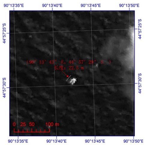
The official, who declined to be named because he isn’t authorized to speak to the media, said one of the objects was estimated to be about the same size as an object captured Tuesday by the Chinese satellite that appeared to be 22 meters (72 feet) by 13 meters (43 feet). However, the official said the French satellite image was fuzzy and very unclear, making it difficult to determine the exact dimensions.
The development will further cement belief that the airliner, carrying 239 passengers and crew, crashed into the ocean after it disappeared from radar on March 8.
A massive search of the southern corridor, led by Australia with the assistance of China, Japan and the US, has been under way for the last four days.
It also emerged on Sunday that, in a telephone conversation with Australian Chief of Defence Force David Hurley, China's PLA chief of staff Fang Fenghui called for both sides to step up cooperation in the search.
Search times were extended into Sunday late evening as weather conditions improved, to locate possible wreckage – linked or not – to the missing Malaysia Airlines jet in the remote stretch of the southern Indian Ocean.
A growing international fleet of aircraft and vessels in an Australia-led Indian Ocean surveillance mission resumed the search on day four in a concentrated area some 2,300 kilometres west of Perth.
Eight aircraft are searching today: four civil jets and four military aircraft are involved in visual operations.
Officials in the state capital Canberra said a sighting by a team member of a wooden pallet was a “possible lead”.
Mike Barton, a rescue coordinator for the Australian Maritime Safety Authority (AMSA), said on Sunday that search teams spotted the wooden pallet “and a number of other items… [including] strapping belts of different lengths.”
“But we have to be very certain that this is a pallet because pallets are used in the shipping industry as well,” Barton said.
It is hoped that other objects of interest identified by Chinese satellites on Saturday can be ruled out or provide clues to investigators still short of answers to what happened to the Boeing 777, and to search teams anxious to narrow search areas and eventually recover flight MH370’s black box voice and flight data recorder.
More than two weeks after the Beijing-bound Malaysia Airlines MH370 disappeared, the new image shows an object 120 kilometres southwest of where suspected wreckage was previously spotted.
AMSA’s Barton said it had been able to search a smaller “defined area” based on two previous satellite images released on Friday showing possible objects in the immediate vicinity.
Aircraft have so far not been able to detect the objects from the fresh sighting. “You only have to be off a few hundred metres in a fast travelling aircraft,” Barton said.
It had been feared that Tropical Cyclone Gillian, due in the area, would make operations “very challenging” for ships, with rough seas and strong currents.
But on Sunday afternoon conditions looked to be improving, although not without bringing new challenges.
“Actually determining what it is from an aircraft at a lot lower altitude looking into the sun, or with the haze, is proving difficult to relocate these items,” Barton added.
Separately, Nasa will reposition satellites to the areas in the southern Indian Ocean to speed-up investigations in the area.
Warren Truss, Australia’s deputy prime minister, said: “I hope…we are able to conclusively say once and for all that we are close to finding where this plane may be located and there can be some kind of closure for families.”
Watch: Australia launches search after objects related to MH370 spotted
However, Malaysian authorities have asked the US for help with underwater surveillance.
In a phone call to defence secretary Chuck Hagel, Malaysia’s defence minister and acting transport minister Hishammuddin Hussein “requested that the US consider providing some undersea surveillance equipment”, Pentagon spokesman Rear Admiral John Kirby said.
Hagel assured his counterpart that he would “assess the availability and utility of military undersea technology for such a task and provide him an update in the very near future”, Kirby said in a statement.
Earlier, Australia’s Maritime Search Agency released a statement saying it was taking “drift modelling” into account in the resumed search for the objects spotted by satellites.
Yesterday, China provided a satellite image to Australia possibly showing a 22.5 metre floating object in the southern Indian Ocean. AMSA plotted the position and it fell within yesterday’s search area. The object was not sighted during yesterday’s search.
 The RNZAF P3 Orion dropped a datum marker buoy to track the movement of the material. Further attempts were made today to establish whether the objects sighted are related to MH370.
Yesterday, China provided a satellite image to Australia possibly showing a 22.5 metre floating object in the southern Indian Ocean. AMSA plotted the position and it fell within yesterday’s search area. The object was not sighted during yesterday’s search.
AMSA has used this information in the development of the search area, taking drift modelling into account."


